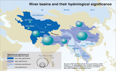
This Cool Map comes from the UNEP/GRID Maps Library. What seems most telling, is that 3 billion+ people rely on glacier melt water flow for their basic water requirements. This is the most stark example I have have seen on the "inland" impact from climate change.
" ...Many of the largest rivers in the Himalayas Hindu Kush region are strongly dependent upon snow and glacial melt for waterflow. Many of the largest rivers in the Himalayas Hindu Kush region are strongly dependent upon snow and glacial melt for waterflow. Except for the fact that glaciers are melting rapidly in many places, we do not have adequate data to more accurately project when and where water scarcity will affect irrigation schemes in full. Making accurate projections is also difficult because of variations in the effects on ground and surface water, as well as on water for urban needs and industrial purposes Furthermore, the cost of water may also increase, seriously complicating the water scarcity question. Recent studies show that cost of water has increased by about 400–500% since 1990 in the Indo-Gangetic Basin of India..."
Full Article - Click Here
Download this graphic in png format, 1812 KB , suitable for web-sites, documents or presentations.
Download this graphic in tif format, 4501 KB, suitable for print and editing.
Download this graphic in jpg format, 1242 KB , suitable for web-sites, documents or presentations.
References / Credits:
(Source: Rees and Collins, 2004; UNEP, 2007).
Link to web-site http://www.grida.no/publications/rr/food-crisis/
Cartographer/Designer Ieva Rucevska, UNEP/GRID-Arendal
Appears in Environmental Food Crisis
Published 2009, Joel Benoit
Link to web-site http://www.grida.no/publications/rr/food-crisis/
Cartographer/Designer Ieva Rucevska, UNEP/GRID-Arendal
Appears in Environmental Food Crisis
Published 2009, Joel Benoit
No comments:
Post a Comment