Very cool link
Friday, October 31, 2008
Wednesday, October 22, 2008
Bean Counters Drink their Way to Presidency

Also found on DirectionsMag's AllPointBlog - this is a neat marketing-to-map gimic. Given many of us are "caffeine-based life forms", kudos to the latest "morning joe" geo-mash-up.
Which way to Mecca?

Credits to DirectionsMag from their "Off the Beaten Path" section - this is an interesting mash up highlighting the distance and prayer times to Mecca.
The green box details provide geo-speciific data. for example:
Current Location
LAT: 33.063924198120645
LONG : 44.560546875
Location Data
Nearest Populated (NP):=Shaykh Muţlaq al Ghuḑayb
Distance From NP=0.6467
Time Zone Data
Time Offset: 2 Hours
Summer Time Offset:3 Hours
Time Zone=Europe/Simferopol
Countrycode=UA
Country name=Ukraine
Governorate=Wāsiţ
Weather Data
Temperature: 31
Humidity: 20
Clouds:overcast
Wind Speed: 08
Wind Direction: 110
Measuring Date/Time:2008-10-22 15:38:00
Elevation Data
Height(USGS):=25
Height(NASA):=34
Cool Geo-Pic: Salt Water Lakes in Antarctica

Another Cool Geo-Pic from NASA's Earth Observatory.
I particularly found the scientific explanation of how salt and fresh water lakes formed thru changes in glacier development.
Quick "Cut & Paste" Highlights:
" ... The scientists believe that several million years ago, Taylor Valley was inundated by the Ross Sea, like a fjord. As climate changed, and the sea retreated, a saltwater lake occupied the valley. Iron-containing salts from the sea water settled in the lake bed. As Taylor Glacier advanced, smothering the lake, it scooped up some of the iron-containing salts. After millions of years, the ancient lake-bed salt deposits have reached the edge of the glacier, and are being squeezed out at the margin.
The researchers also offered an explanation for why Lakes Bonney and Fryxell are saltwater, but Lake Hoare is freshwater. As the Ross Sea retreated, leaving behind a saltwater lake, the Canada Glacier was also advancing. At some point, the researchers think, the Canada Glacier advanced so far into Taylor Valley that it cut off the inland part from the sea. Saltwater lakes were left on either side, and a new freshwater lake, Lake Hoare, formed from glacial melt water on the lower (inland) side of the Canada Glacier. Confirmation of these hypotheses will come from continued drilling of sediment and ice cores in these Dry Valley lakes. ..."
References:Holland, E. (2003, November 4). Explanation Offered For Antarctica’s Blood Falls. The Ohio State University Research Communications Website. Accessed October 8, 2008.
NASA image created by Jesse Allen, using data provided courtesy of NASA/GSFC/METI/ERSDAC/JAROS, and U.S./Japan ASTER Science Team. Caption by Rebecca Lindsey.
NASA image created by Jesse Allen, using data provided courtesy of NASA/GSFC/METI/ERSDAC/JAROS, and U.S./Japan ASTER Science Team. Caption by Rebecca Lindsey.
Thursday, October 16, 2008
Geo-Mash up in Florida politics

Here is a nice example of using google mash ups to geo-visually communicate political information. While I have my presidential leanings in this year's election, this is not to sway anyone to toward either candidate - more to highlight the example of the slick technology for purpose (benefit or sly persuasion - you decide) for communicating local legislative issues via the map. My guess is the RNC is as good at it as the DNC. Its a wonderful way to tie regional issues in a "browsable" format.
For the full website - click here
To see Click2Map's google mash-up tool - click here
The Click2Map blog has some interesting posts on GooCar and Geo-Targeting.
Wednesday, October 15, 2008
Why I need a new car to save the planet

Well, in this case the map says it all.
Taken from ESRI's MapMPG.com (beta) - the site lets you compare how far two different cars can go on one gallon of gas.
My "cut & paste" example compares "my old but paid for truck" – a 1997 Isuzu Trooper contrasted with a burn rate of today's "auto-green darling" - a Toyota Prius.
As soon as the home budget allows for a new car payment, I think the choice of purchase is clear.
Thanks to www.DirectionsMag.com "Off the Beaten Path" article for the link.
Wednesday, October 08, 2008
Cool Geo-Pic: Bouvet Island, South Atlantic Ocean
 Another cool geo-pic from NASA's Earth Observatory.
Click here to view full image (128 kb)
Quick "Cut & Paste" Highlights:
" .... Bouvet Island (in Norwegian, Bouvetøya) is known as the most remote island in the world; Antarctica, over 1600 kilometers (994 miles) to the south, is the nearest land mass. Located near the junction between the South American, African, and Antarctic tectonic plates, the island is mostly formed from a shield volcano—a broad, gently sloping cone formed by thin, fluid lavas—that is almost entirely covered by glaciers. The prominent Kapp (Cape) Valdivia on the northern coastline is a peninsula formed by a lava dome, a volcanic feature built by viscous lavas with a high silica content. It is only along the steep cliffs of the coastline that the underlaying dark volcanic rock is visible against the white snow and ice blanketing the island...."
References:
Astronaut photograph ISS017-E-16161 was acquired on September 13, 2008. with a Nikon D2Xs digital camera fitted with an 800 mm lens, and is provided by the ISS Crew Earth Observations experiment and the Image Science & Analysis Laboratory, Johnson Space Center.
The image was taken by the Expedition 17 crew. The image in this article has been cropped and enhanced to improve contrast. Lens artifacts have been removed. The International Space Station Program supports the laboratory to help astronauts take pictures of Earth that will be of the greatest value to scientists and the public, and to make those images freely available on the Internet.
Additional images taken by astronauts and cosmonauts can be viewed at the NASA/JSC Gateway to Astronaut Photography of Earth. Caption by William L. Stefanov, NASA-JSC.
Cool Geo-Pic: Wetland Damage Along the Gulf Coast

Another brilliant NASA image from the Earth Observatory.
Click here to view full image (650 kb)
Quick "Cut & Paste" Highlights:
" .... This photo-like image of the Texas and Louisiana coasts shows the impact of Hurricane Ike’s powerful storm surge on coastal wetlands. Hurricane Ike came ashore over southeast Texas on September 13, 2008, bringing with it a wall of water that stretched from Galveston, Texas, across all of coastal Louisiana. The storm’s surge covered hundreds of kilometers of the Gulf Coast because Ike was a large storm, with tropical-storm-strength winds stretching more than four hundred kilometers from the center of the storm. The strongest storm surge devastated Galveston and the Bolivar Peninsula. Though it was not as hard hit, coastal Louisiana—still trying to dry out from Hurricane Gustav—suffered as well.... "
References:
National Hurricane Center. (2008, September 13). Hurricane Ike. NOAA National Weather Service. Accessed October 1, 2008.
NASA image courtesy Jeff Schmaltz, MODIS Rapid Response Team at NASA GSFC. Caption by Holli Riebeek.
Cool Geo-Pic: Roan Plateau, Colorado

Cool Geo-Pic: Roan Plateau, Colorado
Quick "Cut & Paste" Highlights:
Western Colorado’s Roan Plateau contains a variety of natural resources and scenic terrain: high ridges, deep valleys, waterfalls, cutthroat trout, mountain lions, bears, rare plants, and oil and natural gas. On September 25, 2008, the Moderate Resolution Imaging Spectroradiometer (MODIS) on NASA’s Terra satellite captured this image of the region through nearly cloud-free skies.
References:
U.S. Bureau of Land Management. (2008, March 13). Roan Plateau Resource Management Plan and Final EIS. Accessed October 2, 2008.
NASA image courtesy MODIS Rapid Response Team, Goddard Space Flight Center. Caption by Michon Scott.
Cool Geo-Pic: Flooding from Hurricane Ike in Texas
Another great NASA "before-after"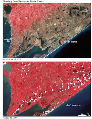 image: Flooding from Hurricane Ike in Texas
Large images
September 28, 2008 (3.6 MB JPEG)
August 15, 2006 (3.2 MB JPEG)
Quick "Cut & Paste" Highlights:
" .... Hurricane Ike came ashore along the U.S. Gulf Coast on September 13, 2008, and the storm’s eye narrowly missed Galveston and Houston. Although the storm produced tremendous damage in both cities, perhaps the greatest damage was caused by the storm surge, which inundated the coastline near Galveston. The storm surge was greatest east of Galveston, reaching 4.6 meters (15 feet) above sea level. The area devastated by the storm surge includes coastline immediately east of Galveston Bay.
These images acquired by the Advanced Spaceborne Thermal Emission and Relfection Radiometer (ASTER) on NASA’s Terra satellite show part of the area scoured by Hurricane Ike. The bottom image, acquired August 15, 2006, shows the region two years prior to Ike’s landfall. The top image, acquired September 28, 2008, shows the region about two weeks after the storm surge.... "
Full Article - Click Here
References:
Aigner, E., Bornemeier, J., Burgess, J., Huang J., Iaboni L., Park H. (2008, September 13). In Ike’s wake. The New York Times. Accessed September 30, 2008.
Dewan, S. (2008, September 15). On peninsula in the storm: No way out. The New York Times. Accessed September 30, 2008.
Drye, W. (2008, September 26). Why Hurricane Ike’s “Certain Death” warning failed. National Geographic News. Accessed September 30, 2008.
Urbina, I. (2008, September 15). After surviving storm, fleeing a fetid, devastated Galveston. The New York Times. Accessed September 30, 2008.
Wikipedia. (2008, September 21). High Island, Texas. Accessed September 30, 2008.
NASA image created by Jesse Allen, using data provided courtesy of
NASA/GSFC/METI/ERSDAC/JAROS, and U.S./Japan ASTER Science Team. Caption by Michon Scott.
 image: Flooding from Hurricane Ike in Texas
Large images
September 28, 2008 (3.6 MB JPEG)
August 15, 2006 (3.2 MB JPEG)
Quick "Cut & Paste" Highlights:
" .... Hurricane Ike came ashore along the U.S. Gulf Coast on September 13, 2008, and the storm’s eye narrowly missed Galveston and Houston. Although the storm produced tremendous damage in both cities, perhaps the greatest damage was caused by the storm surge, which inundated the coastline near Galveston. The storm surge was greatest east of Galveston, reaching 4.6 meters (15 feet) above sea level. The area devastated by the storm surge includes coastline immediately east of Galveston Bay.
These images acquired by the Advanced Spaceborne Thermal Emission and Relfection Radiometer (ASTER) on NASA’s Terra satellite show part of the area scoured by Hurricane Ike. The bottom image, acquired August 15, 2006, shows the region two years prior to Ike’s landfall. The top image, acquired September 28, 2008, shows the region about two weeks after the storm surge.... "
Full Article - Click Here
References:
Aigner, E., Bornemeier, J., Burgess, J., Huang J., Iaboni L., Park H. (2008, September 13). In Ike’s wake. The New York Times. Accessed September 30, 2008.
Dewan, S. (2008, September 15). On peninsula in the storm: No way out. The New York Times. Accessed September 30, 2008.
Drye, W. (2008, September 26). Why Hurricane Ike’s “Certain Death” warning failed. National Geographic News. Accessed September 30, 2008.
Urbina, I. (2008, September 15). After surviving storm, fleeing a fetid, devastated Galveston. The New York Times. Accessed September 30, 2008.
Wikipedia. (2008, September 21). High Island, Texas. Accessed September 30, 2008.
NASA image created by Jesse Allen, using data provided courtesy of
NASA/GSFC/METI/ERSDAC/JAROS, and U.S./Japan ASTER Science Team. Caption by Michon Scott.
Subscribe to:
Comments (Atom)