I stumbled across AbovInc.com in one of my GIS- e-magazines. They have taken a long standing belief that GIS is both art and science .... to a fascinating business model, repesenting stunningly beautiful satellite imarery as art product.
Their work, currently represented under Stuart Black's and Larry Ammann's collection - had me enspelled for hours on their website. Now I need a second job to buy up the collection!
Attached is an image of the Chicago area, a region dear to my heart - as I spent several years there working, married my wife and had our first child while living in Oak Park, IL.
Please check out the full collection at www.AbovInc.com
Below for your pleasure are three samples I swiped (with permission) to show off the beauty of the collection. Now go buy one. 
 This image transforms the one of the most barren regions of the planet into a myriad of color- I have shamelessly 'cut and paste' the caption below. I contacted the Director Josh and I highly recommend you check out their website at: www.AbovInc.com
From Larry Ammann's Collection at http://abovinc.com/larry_ammann/volcano.htmlAnother abstract painting by Earth. This image shows a portion of the Arabian Desert in the Ar-Rub al-Khali (The Empty Quarter) of southern Saudi Arabia and northern Yemen. The dry river channels in the lower portion of this image are ancient features formed when this region had a wetter climate. The linear dunes are generated by strong prevailing winds blowing across the dune fields and the large formation just below the dunes is a dry delta. The dunes are slowly covering up the older erosion channels, while occasional rains in the mountains south of this region wash sediments into the delta. The mixing of materials from these sources produces the green-colored sand between the dunes and the delta. These colors are not real since most of what is seen in this image was derived from the infrared portion of the spectrum.
The only evidence of mankind's presence in this image is an airstrip approximately 1 mile long that is nestled between two rows of dunes near the top of the image, a camp 6 dune rows south of the airstrip, some vehicle tracks northeast of the delta, and a strange diamond-shaped feature just left of the lower part of the delta.
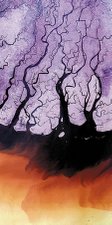
 This image transforms the muddy shades of a river delta into almost cosmic spillings of modern art - I have shamelessly 'cut and paste' the caption below. I contacted the Director Josh and I highly recommend you check out their website at: www.AbovInc.com
From Stuart Black's Collection at http://abovinc.com/stuart_black/irrawaddy.html... the Road to Mandalay or Irrawaddy River in Myanmar (Burma) has a delta region characteristic of many rivers in South East Asia that carry monsoon runoff from the Himalayas. The piece depicts the Mouths of the Irrawaddy during the wet season when torrential rains wash sediments along the complex arrangement of river channels and into the Andaman Sea. This produces a cloudy, air-brush like effect in the image - the darker the water the heavier the sediment load. Shades of BLUE, LILAC and PURPLE represent varying degrees of vegetation growth and moisture content
 This image is my favorite as a explosively color contrast to the cold stark reality of the true geography.
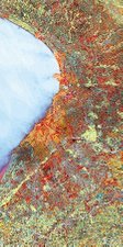
For the detailed description - I have shamelessly 'cut and paste' the caption below. I contacted the Director Josh and I highly recommend you check out their website at: www.AbovInc.com
Description: from the Stuart Black Collection of AbovInc at http://abovinc.com/stuart_black/malsapina.htmlMalsapina Glacier is a classic fan-shaped outlet glacier fringed by a coastal plain. The glacier is about 65 km wide at its lowest point and just 25m above sea level. It covers over 3,800 km_ of southeast Alaska near the international border with Canada.
The image was created using thermal measurements of the surface and illustrates that even during the summer months the relative temperature of the sea is higher than the land, resulting in the RED color of the sea. The extensive ice fields appear BLUE and the rougher, debris-filled edges of the glacier GREEN.
 I stumbled across AbovInc.com in one of my GIS- e-magazines. They have taken a long standing belief that GIS is both art and science .... to a fascinating business model, repesenting stunningly beautiful satellite imarery as art product.