Showing posts with label agriculture. Show all posts
Showing posts with label agriculture. Show all posts
Thursday, January 12, 2017
Mapping Agriculture: 2015 results for US Direct Food Sales
Bringing it Home at the End of the Year
http://flip.it/65SVRy


Thursday, August 21, 2014
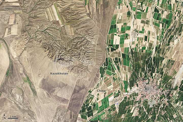
Cool Geo-Pic: Border Result of Different Agricultural Use
Found the cool geo-pic from the familiar NASA Earth Observatory. Fascinating how the different demands & policies for agricultural land use can produce such a stark contrast.
Geo-Pic:
Quick "Cut & Paste" Description:
"....The border between the two countries is defined by land-use policies. In China, land use is intense. Only 11.62 percent of China’s land is arable. Pressed by a need to produce food for 1.3 billion people, China farms just about any land that can be sustained for agriculture. Fields are dark green in contrast to the surrounding arid landscape, a sign that the agriculture is irrigated. As of 2006, about 65 percent of China’s fresh water was used for agriculture, irrigating 629,000 square kilometers (243,000 square miles) of farmland, an area slightly smaller than the state of Texas....."
".....The story is quite different in Kazakhstan. Here, large industrial-sized farms dominate, an artifact of Soviet-era agriculture. While agriculture is an important sector in the Kazakh economy, eastern Kazakhstan is a minor growing area. Only 0.03 percent of Kazakhstan’s land is devoted to permanent agriculture, with 20,660 square kilometers being irrigated....."
Credits: Source link
Geo-Pic:
Quick "Cut & Paste" Description:
"....The border between the two countries is defined by land-use policies. In China, land use is intense. Only 11.62 percent of China’s land is arable. Pressed by a need to produce food for 1.3 billion people, China farms just about any land that can be sustained for agriculture. Fields are dark green in contrast to the surrounding arid landscape, a sign that the agriculture is irrigated. As of 2006, about 65 percent of China’s fresh water was used for agriculture, irrigating 629,000 square kilometers (243,000 square miles) of farmland, an area slightly smaller than the state of Texas....."
".....The story is quite different in Kazakhstan. Here, large industrial-sized farms dominate, an artifact of Soviet-era agriculture. While agriculture is an important sector in the Kazakh economy, eastern Kazakhstan is a minor growing area. Only 0.03 percent of Kazakhstan’s land is devoted to permanent agriculture, with 20,660 square kilometers being irrigated....."
Credits: Source link
- BBC News (2010, January 30) Kazakhs protest against China farmland lease. Accessed July 9, 2014.
- Earth Observatory (2013, September 25) Fall harvest in Kazakhstan. Accessed July 9, 2014.
- Encyclopedia of Earth (2013, August 25) Land use profile of China. Accessed July 9, 2014.
- Fragile Oasis (2011, September 7) Borders from space. Accessed July 9, 2014.
- United States Central Intelligence Agency (2014, June 22) The world factbook: China. Accessed July 9, 2014.
- United States Central Intelligence Agency (2014, June 22) The world factbook: Kazakhstan. Accessed July 9, 2014.
NASA Earth Observatory image by Robert Simmon, using Landsat data from the U.S. Geological Survey. Caption by Holli Riebeek.
- Instrument(s): Landsat 8 - OLI
Tuesday, October 16, 2012
Mapping Precision Agriculture's Future - Video & Article on IBM's Big Thunder project
Video on IBM's Deep Thunder - using predictive modeling to impact the "business of weather" (see below).
Good article reference on "Precision agriculture - Using predictive weather analytics to feed future generations"
"Cut & Paste" highlights:
"...By 2050, it’s expected that the world’s population will reach 9.2 billion people, 34 percent higher than today. Much of this growth will happen in developing countries like Brazil, which has the largest area in the world with arable land for agriculture. To keep up with rising populations and income growth, global food production must increase by 70 percent in order to be able to feed the world...."
Full credits to:
Meet the researchers

Ulisses Mello
Distinguished Engineer,
Associate Director,
IBM Research - Brazil
Lloyd Treinish
Senior Technical Staff Member,
Chief Scientist - Deep Thunder,
IBM Research - Watso
Subscribe to:
Posts (Atom)