Esri News Feed

Friday, May 30, 2008

Join DayJet - Free Membership


I always told you that knowing me had certain benefits and today I can prove it. We have been provided with a great opportunity to share DayJet with our friends and family and the Company is allowing us to waive the membership fee. Now you have no excuses, it’s time to experience DayJet.

If you are interested in learning more and/or signing up, check out this microsite at
www.dayjet.com/friends which will provide you with a brief overview. Be sure to enter my promotion code 10000339 in order for the system to waive the membership fee. You need to sign-up by June 30, 2008 in order to take advantage of this offer. Folks who are flying with DayJet are loving it.

I also have provided the following links to some recent video and news coverage on DayJet that you might find interesting. The final link is for testimonials from current DayJet customers:

Here is another great link from our site that helps explain how pricing works...

http://www.dayjet.com/Services/TVPIntro.aspx

Give me your thoughts and tell me what you think. I’ll call you in a few days to follow-up. As always, please forward this to anyone you think may want to join DayJet.


Thanks,

Sinam Al-Khafaji
Marketing Cartographer & Market Planner
Founding Member, DayJet

Sinam@DayJet.com
Desk 561.322.2286
Cell 561.665.0278


Tuesday, May 27, 2008

Cool Geo-Pic: Lake Formation in the Aftermath of Magnitude 7.9 Earthquake


Another Cool Geo-Pic from NASA's Earth Observatory. From earthquakes, comes lakes ....

Cut & Paste Description:

" ... Within days of the magnitude 7.9 earthquake that shook China’s Sichuan Basin, floods became a hazard. The earthquake and its aftershocks sent earth and rock tumbling down mountains into rivers, creating natural dams behind which lakes quickly built up. As of May 19, 2008, 21 lakes had formed throughout the basin, said China Daily.... "


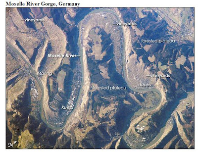
Cool Geo-Pic: Wine country in Moselle River Gorge, Germany


Another Cool GeoPic from NASA's Earth Observatory.
Always wondered where a good German Riesling came from .....
Cut & Paste description:
" Within the narrow and very steep valley, those slopes which face south and west are best for grapes. The north-facing slopes not only receive less direct sunshine, but the deep shadows of the canyon walls fall on them sooner in the day. These shadows are visible on the canyon wall opposite Kroev and elsewhere, where they make the river difficult to see. The vine-covered slopes, with very small plot sizes, appear as light grays and light greens along most of the gorge slopes. In this view, slopes around the villages of Kroev, Kuess, and Maring enjoy the best south-facing aspect.... "

Monday, May 19, 2008

When Geo Strikes Back: Earthquake near Chengdu, China


This image helped me map out " devastation to geography". The death toll makes this a sobering map.


Cut & Paste Description:

" At 2:28 p.m. local time (06:28 UTC) on May 12, 2008, an earthquake with an estimated magnitude of 7.9 struck China’s Sichuan Province. The quake was felt throughout much of China, as well as parts of Taiwan, Thailand, and Vietnam. Within 24 hours, the death toll stood at 12,000, and was expected to rise significantly as search-and-rescue efforts continued.... "


"Old School" Geo-Pic: William Smith's Geological Map of England


This image wins the "Old School" Geo-Pic Image posting - as before 'pics', we drew our views of the world with 'sticks' (pencils, canoe navigational stick sculptures, lines in the sand, etc.) As most, this comes from NASA's Earth Observatory site.

Also, it emphasizes the long standing relationship of maps to commerce; i.e. right or wrong - we most often explore for gains.


Cut & Paste Description:

" Before the late eighteenth century, residents of England didn’t necessarily take much interest in the rocks under their feet. The arrival of the Industrial Revolution, however, drew the attention of the country’s entrepreneurs downward. England’s industrialists began plunging deep underground for coal—the fossilized remains of ancient swamps—and carving canals across the countryside to transport it efficiently. In this environment, a geologist named William Smith managed to marry his knowledge of rock layers with his love of fossils.... "


" The eventual outcome of Smith’s research was A Geological Map of England and Wales and Part of Scotland, first published in 1815. On a scale of 5 miles per inch, the map measured 6 feet by 8 feet 6 inches. It was not the world’s first geologic map, but it was the first to map such a large area in such detail.... "


Cool Geo-Pic: Chile's Chaiten Volcano Erupts


Another Cool Geo-Pic from NASA's Earth Observatory:

Two points that amaze me. The first, this supposed dominant volcano last erupted several millennia BC. The second, the ash plume flow across the entire South American continent to the Atlantic Ocean.

Large Images:
True color (3.85 MB jpg)
Infrared (5.25 MB jpg)

Quick Cut & Paste Description:
" Three days after its surprise eruption on May 2, the Chaitén volcano of southern Chile was still pumping out dense clouds of ash. The plume stretches east from the peak in this pair of images, taken on May 5, 2008, by the Moderate Resolution Imaging Spectroradiometer (MODIS) on NASA’s Terra satellite. ....

" The eruption that started on May 2 was unexpected because Chaitén was thought to have been dormant. Radiocarbon dating of the last lava flow from the volcano suggests that Chaitén last erupted in 7420 BC, plus or minus 75 years, says the Smithsonian’s Global Volcanism Program...."

Full Story at: http://earthobservatory.nasa.gov/Newsroom/NewImages/images.php3?img_id=18020

Tuesday, May 06, 2008

DayJet in Sarasota & Jacksonville, FL


Maps of Religion - a historical timeline


This is a neat site that provides animation to historical map series - as a timeline of rolling events.
This particle link is on the History of Religion - and the site creator's have a nice selection of other compilations.
Other compilations include the History of Democracy, various Gulf War scenarios and other animated timeline visualizations overlayed on geography .
Click thru and donate generously - good work.

First Rule of City Planning - No Volcanoes

Another NASA Earth Observatory nomination for the cool Geo-Pic also follows a good rule of city planning - avoid volcanoes.

Cut & Paste Description:
" This astronaut photograph highlights Cerro (Spanish for “hill”) Culiacan, part of the 50,000 km2 Michoacán-Guanajuato volcanic field of west-central Mexico. The volcanic field contains over 1,400 known vents, with cinder cones, steep, cone-shaped hills, being the dominant landform.
Cerro Culiacan however, is a shield volcano, a more gently sloping mound formed by basaltic lavas. Cerro Culiacan most likely formed during the Pleistocene Epoch approximately 10,000 to 2 million years ago. Shield volcanoes in the Michoacán-Guanajuato field tend to have steeper slopes than similar volcanic structures elsewhere (namely Iceland; this is perhaps due to slightly thicker or higher-viscosity lavas), and the 1,100-meter high Cerro Culiacan is no exception.... "

Un-cool Geo-Pic: Coal Sludge Impoundments, West Virginia


This geo-pic is decidedly "uncool". These are literally dammed reservoirs of goal sludge.
From NASA's Earth Observatory.

Click here to view full image (4793 kb)

Cut & Paste Description:

" Since the mid- to late 1990s, the number and size of coal mines known as mountaintop removal mines increased dramatically in parts of Virginia, West Virginia, Pennsylvania, and Kentucky. Mountaintop coal mining follows a general process of deforestation, mountaintop removal with explosives and earth-moving machinery, debris sorting to extract the coal, and rinsing the newly mined coal. "

" This final step creates sludge that contains coal dust and other sediment, and may contain heavy metals or chemicals that would impair water quality in streams and rivers if it were allowed to flow freely off the mine site. To keep any hazardous materials out of local water supplies, mine operators contain the coal sludge in nearby valleys, behind huge earthen dams known as valley fills. On March 18, 2006, GeoEye’s Ikonos satellite acquired this high-resolution satellite image of two sludge impoundments in Boone County, West Virginia. (The mine from which the material was taken does not appear in this image; it lies to the northeast.) .... "

" Although coal impoundments have a relatively low rate of failure, their extreme size—some hold more than a billion gallons of sludge—makes any breach potentially devastating. In 2000, Congress directed the National Research Council to undertake a review of mining and engineering techniques related to these structures and make recommendations for improvement after a sludge impoundment in Kentucky collapsed into an underground mine and poured 250 million gallons of sludge into rivers and streams. No human lives were lost, but the environmental damage was extreme; some streams were buried to a depth of five feet in sludge.
The Earth Observatory’s feature article
Coal Controversy in Appalachia has additional information about the land surface impacts of mountaintop coal mining in West Virginia and neighboring states.... "


Full article: http://earthobservatory.nasa.gov/Newsroom/NewImages/images.php3?img_id=18008

Monday, May 05, 2008

Cool Geo-Pic: Burn Scar Near Fort Carson, Colorado


Another cool Geo-Pic from NASA's Earth Observatory.
Cut & Paste Description:
" A fast-moving brushfire raced across the Colorado landscape near Fort Carson in mid-April. The blaze forced evacuations in the area and took more than a week—which included a beneficial snow storm—to contain. The fire scorched more than 9,000 acres according to news reports, and a pilot lost his life while helping to fight the fire.... "

Cool Geo-Pic: Tokyo at Night


Another cool Geo-Pic from NAS's Earth Observatory.

Cut & Paste Description:
" Images of city lights at night taken by astronauts are among the most interesting visual reminders of how humans have transformed Earth’s surface. This nighttime photograph of Tokyo, Japan, was taken by International Space Station astronaut Dan Tani on February 5, 2008. The heart of the city is brightest, with ribbons of lights radiating outward from the center along streets and railways. The regularly spaced bright spots along one of the ribbons heading almost due west out of the downtown area are probably train stations along a public transit route. The lights of Tokyo are a cooler blue-green color than many other world cities. The color results from the more widespread use of mercury vapor lighting as opposed to sodium vapor lighting, which produces an orange-yellow light.... "

Cool Geo-Pic: The Nardo Ring


Another cool Geo-Pic from NASA's Earth Observatory.
Cut & Paste Description:
" You might associate southern Italy with sunny cloudless skies, Mediterranean waters, and sandy beaches, and certainly those things are on display in this image. But for anyone interesting in knowing just how fast a car can go, southern Italy might call to mind the Nardò Ring. The Nardò Ring is a circular track that is 12.5 kilometers (7.8 miles) in circumference, and steeply banked to minimize the amount of steering a driver has to do. For a car moving at 200 miles per hour (about 320 kilometers per hour), the track is like an infinitely long straight road, says Motor Trend. Car manufacturers and racers use the track to test a car’s top speed.... "

Cool Geo-Pic: Gulf of St. Lawrence


Another Cool Geo-Pic from NASA's Earth Observatory.
Cut & Paste Description:
" Winter had started to release its grip on the Gulf of St. Lawrence when the Moderate Resolution Imaging Spectroradiometer (MODIS) on NASA’s Terra satellite captured this photo-like image on April 7, 2008. Swirling clouds over chunky fields of sea ice ­provide a stark contrast to the deep black water of the gulf. The surrounding winter-brown landscape is still coated in white snow and ice except for southern Nova Scotia, which is starting to flush green with early spring foliage. The scene would have been much different, more uniformly white, if taken a month or two earlier. In the deep of winter, sea ice claims most of the gulf, while snow covers the land.... "

Cool Geo-Pic: Lonar Crater, India


Another cool Geo-Pic from the NASA Earth Observatory:

Click here to view full image (3897 kb)

Cut & Paste Description:


"India’s Lonar Crater began causing confusion soon after it was identified in 1823 by a British officer named C.J.E. Alexander. Lonar Crater sits inside the Deccan Plateau—a massive plain of volcanic basalt rock leftover from eruptions some 65 million years ago. Its location in this basalt field suggested to some geologists that it was a volcanic crater. Today, however, Lonar Crater is understood to result from a meteorite impact that occurred between 35,000 and 50,000 years ago...."

Full article: http://earthobservatory.nasa.gov/Newsroom/NewImages/images.php3?img_id=17994

Cool Geo-Pic: Harrat Khaybar Volcanic Field


Another cool Geo-Pic from the NASA Earth Observatory.
A quick cut & paste description:
"The western half of the Arabian Peninsula contains not only large expanses of sand and gravel, but extensive lava fields known as haraat (harrat for a named field). One such field is the 14,000-square-kilometer Harrat Khaybar, located approximately 137 kilometers to the northeast of the city of Al Madinah (Medina). The volcanic field was formed by eruptions along a 100-kilometer, north-south vent system over the past 5 million years. The most recent recorded eruption took place between 600–700 AD...."