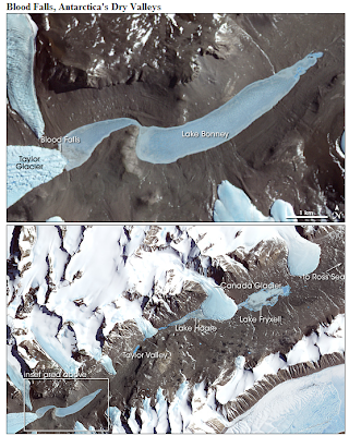
Another Cool Geo-Pic from NASA's Earth Observatory.
I particularly found the scientific explanation of how salt and fresh water lakes formed thru changes in glacier development.
Quick "Cut & Paste" Highlights:
" ... The scientists believe that several million years ago, Taylor Valley was inundated by the Ross Sea, like a fjord. As climate changed, and the sea retreated, a saltwater lake occupied the valley. Iron-containing salts from the sea water settled in the lake bed. As Taylor Glacier advanced, smothering the lake, it scooped up some of the iron-containing salts. After millions of years, the ancient lake-bed salt deposits have reached the edge of the glacier, and are being squeezed out at the margin.
The researchers also offered an explanation for why Lakes Bonney and Fryxell are saltwater, but Lake Hoare is freshwater. As the Ross Sea retreated, leaving behind a saltwater lake, the Canada Glacier was also advancing. At some point, the researchers think, the Canada Glacier advanced so far into Taylor Valley that it cut off the inland part from the sea. Saltwater lakes were left on either side, and a new freshwater lake, Lake Hoare, formed from glacial melt water on the lower (inland) side of the Canada Glacier. Confirmation of these hypotheses will come from continued drilling of sediment and ice cores in these Dry Valley lakes. ..."
References:Holland, E. (2003, November 4). Explanation Offered For Antarctica’s Blood Falls. The Ohio State University Research Communications Website. Accessed October 8, 2008.
NASA image created by Jesse Allen, using data provided courtesy of NASA/GSFC/METI/ERSDAC/JAROS, and U.S./Japan ASTER Science Team. Caption by Rebecca Lindsey.
NASA image created by Jesse Allen, using data provided courtesy of NASA/GSFC/METI/ERSDAC/JAROS, and U.S./Japan ASTER Science Team. Caption by Rebecca Lindsey.
No comments:
Post a Comment