 image: Flooding from Hurricane Ike in Texas
Large images
September 28, 2008 (3.6 MB JPEG)
August 15, 2006 (3.2 MB JPEG)
Quick "Cut & Paste" Highlights:
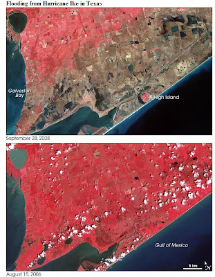
" .... Hurricane Ike came ashore along the U.S. Gulf Coast on September 13, 2008, and the storm’s eye narrowly missed Galveston and Houston. Although the storm produced tremendous damage in both cities, perhaps the greatest damage was caused by the storm surge, which inundated the coastline near Galveston. The storm surge was greatest east of Galveston, reaching 4.6 meters (15 feet) above sea level. The area devastated by the storm surge includes coastline immediately east of Galveston Bay.
These images acquired by the Advanced Spaceborne Thermal Emission and Relfection Radiometer (ASTER) on NASA’s Terra satellite show part of the area scoured by Hurricane Ike. The bottom image, acquired August 15, 2006, shows the region two years prior to Ike’s landfall. The top image, acquired September 28, 2008, shows the region about two weeks after the storm surge.... "
Full Article - Click Here
References:
Aigner, E., Bornemeier, J., Burgess, J., Huang J., Iaboni L., Park H. (2008, September 13). In Ike’s wake. The New York Times. Accessed September 30, 2008.
Dewan, S. (2008, September 15). On peninsula in the storm: No way out. The New York Times. Accessed September 30, 2008.
Drye, W. (2008, September 26). Why Hurricane Ike’s “Certain Death” warning failed. National Geographic News. Accessed September 30, 2008.
Urbina, I. (2008, September 15). After surviving storm, fleeing a fetid, devastated Galveston. The New York Times. Accessed September 30, 2008.
Wikipedia. (2008, September 21). High Island, Texas. Accessed September 30, 2008.
NASA image created by Jesse Allen, using data provided courtesy of
NASA/GSFC/METI/ERSDAC/JAROS, and U.S./Japan ASTER Science Team. Caption by Michon Scott.
No comments:
Post a Comment