Well, so now we know where is started....
Cut & Paste Highlights:
" ... Unlike the water in a sink or a bathtub, the water level in Earth’s oceans is not the same everywhere; sea level varies with location and time. On time spans of hours to days, sea level is influenced by tides, winds, and waves, including storm surges. Sea level rises when oceans warm, and it drops when they cool (because water expands when it heats up and contracts when it cools). Regional variations in sea level can persist for many years, even a decade. Underlying all these changes is the slower rise and fall in global average sea level as ice ages recede and advance over millenia.
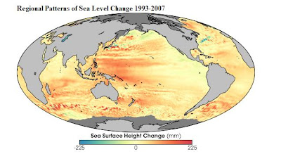
This map shows global patterns of changes in sea level (sea surface height) measured by satellite-based altimeters (Topex and Jason 1 satellites) from 1993 through the end of 2007. Places where the sea surface height increased up to 225 millimeters (about 8.9 inches) are shown in dark red; places where sea level dropped are blue. The most widespread change in sea level over this time period was an increase in the Western Pacific sea surface height. During the period spanned by this image, a climate pattern called the Pacific Decadal Oscillation was in its warm phase, and sea surface temperatures were above average in much of the basin. Thermal expansion during this warm phase would be consistent with a rise in sea level...."
Full Article:
http://earthobservatory.nasa.gov/Newsroom/NewImages/images.php3?img_id=18075
No comments:
Post a Comment