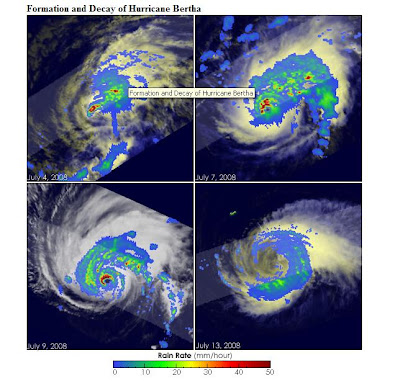
Another Cool Geo-Pic from NASA's Earth Observatory.
now living in Florida nearly sixteen years, you appreciate the power of the massive storms with your livelihood in mind.
Large images
July 4, 2008 (238 kB JPEG)
July 7, 2008 (212 kB JPEG)
July 9, 2008 (181 kB JPEG)
July 13, 2008 (136 kB JPEG)
Cut & Paste" Highlights:
"... This series of images chronicles the development and decay of the first hurricane of the 2008 Atlantic hurricane season, Hurricane Bertha. The images were taken by the Tropical Rainfall Measuring Mission (TRMM) satellite, which uses microwave and radar sensors to see both the swirling clouds and bands of rain that define the structure of the storm...."
References:
National Hurricane Center. Hurricane Bertha advisory archive. Accessed July 15, 2008.
Roberts, E. and McFadden, D. (2008, July 15). Tropical Storm Bertha rakes Bermuda. Associated Press. Accessed July 15, 2008.
Images produced by Hal Pierce and caption by Steve Lang and Holli Riebeek.
No comments:
Post a Comment