This is the blog of a modern day Cartographer thrown into the business world. Over the course of my journeyman's career I have wandered through positions in government, news agencies, consulting corporations and rogue start ups. The hard-earned working theory I have developed is simple. In life, communication is hard work. In business, effective communication is critical. Hence, this blog parallels the location Intelligence practices on www.GeoSteppes.com.
Esri News Feed
Sunday, March 30, 2008
Cool Geo-Pic: Al Wadj Bank, Saudi Arabia

From NASA's Earth Observatory:
Click here to view full image (431 kb)
Saudi Arabia boasts the most coral reefs of any Middle Eastern country, as it includes coastline along both the Red Sea and the Persian Gulf. This high-resolution astronaut photograph shows part of the Al Wadj Bank, located along the northern Red Sea coast. Despite the relatively high salinity of Red Sea water (compared to other oceans), approximately 260 species of coral have been documented in the region. Large tracts of the Saudi Arabian coastline are undeveloped, and reefs in these areas are in generally good ecological health. However, reefs located near large urban centers such as Jeddeh have suffered degradation due to land reclamation (dredging and filling), pollution, and increased sediment runoff from land.
Full story at:
Cool Geo-Pic: Arctic Sea Ice Younger than Normal

From NASA's Earth Observatory:
Click here to view full image (270 kb)
In the Arctic, sea ice extent fluctuates with the seasons. It reaches its peak extent in March, near the end of Northern Hemisphere winter, and its minimum extent in September, at the end of the summer thaw. In September 2007, Arctic sea ice extent was the smallest area on record since satellites began collecting measurements about 30 years ago.
Although a cold winter allowed sea ice to re-cover much of the Arctic in the months that followed, this pair of images reveals that conditions were far from normal. The February 2008 ice pack (right) contained much more young ice than the long-term average (left). In the past, more ice survived the summer melt season and had the chance to thicken over the following winter. This perennial ice generally gets thicker each winter, which makes it more likely to survive the next summer.
Full story at: http://earthobservatory.nasa.gov/Newsroom/NewImages/images.php3?img_id=17975
Labels:
Geo-Pic
Cool Geo-Pic: Nicholson Crater, Canada

From NASA's Earth Observatory:
Click here to view full image (4000 kb)
Some 400 million years ago, a meteor struck Earth in what is now Canada’s Northwest Territories. Plate tectonics have rearranged Earth’s continents considerably since then, and the 12.5-kilometer- (7.8-mile-) wide crater is now Nicholson Lake, one of many small lakes that dot the sub-arctic, glacier-scoured landscape.
Labels:
Geo-Pic
Cool Geo-Pic: Deadly rains in Midwest

From NASA's Earth Observatory eblast:
An early spring storm system advanced out of the Southern Plains in mid-March 2008, causing widespread flooding. Strong southerly winds developed ahead of an area of low pressure located over the Southern High Plains and drew moisture up from the Gulf of Mexico across Texas and Louisiana. This warm, moist air collided with a frontal boundary (the boundary between two air masses of different temperature, pressure, or humidity) that draped across central Texas into central Missouri. The convergence produced repeated bouts of thunderstorms and heavy rain from central Texas through Oklahoma and into Kansas and Missouri.
Labels:
Geo-Pic
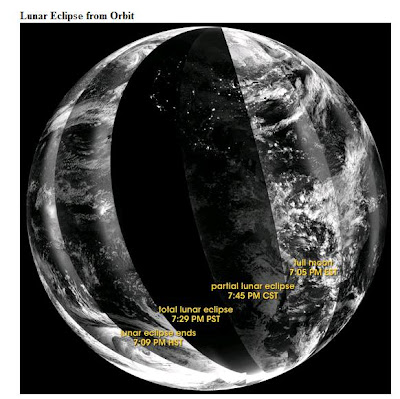
Cool Geo-Pic: Lunar Eclipse from Orbit

Click here to view full image (5511 kb)
From one of my NASA Earth Observatory News eblasts:
On February 20, 2008, sky gazers from the central Pacific to Africa saw the full Moon turn a striking red as it passed into Earth’s shadow. From space, the lunar eclipse deepened the darkness of the night. The Defense Meteorological Satellite Program’s (DMSP) F16 satellite captured this view of the eclipse as the satellite flew over the nighttime side of the Earth in a series of overpasses. The earliest overpasses are on the right, where bright light from the full moon reflects off clouds over the Atlantic Ocean and the east coasts of North and South America.
Full story at: http://earthobservatory.nasa.gov/Newsroom/NewImages/images.php3?img_id=17963
Labels:
Geo-Pic
Subscribe to:
Comments (Atom)