By Tom Carden - link to his blogTomC's Processing Sketchbook
http://www.tom-carden.co.uk/p5/
I first became aware of this site from one of my GIS e-magazines.
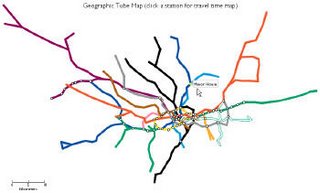
Its a web application that provides a visual representation of travel times on the London Underground. By clicking along a route station - the map view morphs to represent to travel time, with radial measurments in ten minute intervals.
Travel Time Tub Map http://www.tom-carden.co.uk/p5/tube_map_travel_times/applet/
by Tom Carden - link to his blogTomC's Processing Sketchbook http://www.tom-carden.co.uk/p5/
While the developer lists a horde of disclaimers on his beta site, it is a phenomenal mix of a graphical fluid presentation of space and time.
The first image is the base map of the London tube line.
The second is is the time alertation base on tube travel times. In the below image, I selected Colindale station. I also like the morphed map time image from Blackhorse Road station (try it http://www.tom-carden.co.uk/p5/tube_map_travel_times/applet/).

This can be user selected via mouse, on thru a station pull down menu.
Neat fun stuff. Happy Friday.
No comments:
Post a Comment