Esri News Feed

Tuesday, October 16, 2012

Mapping Precision Agriculture's Future - Video & Article on IBM's Big Thunder project

Video on IBM's Deep Thunder - using predictive modeling to impact the "business of weather" (see below). 


Good article reference on "Precision agriculture - Using predictive weather analytics to feed future generations"

"Cut & Paste" highlights:
"...By 2050, it’s expected that the world’s population will reach 9.2 billion people, 34 percent higher than today. Much of this growth will happen in developing countries like Brazil, which has the largest area in the world with arable land for agriculture. To keep up with rising populations and income growth, global food production must increase by 70 percent in order to be able to feed the world...."

Full credits to: 

Meet the researchers

  • Thumnail image of Ulisses Mello

    Ulisses Mello

    Distinguished Engineer,
    Associate Director,
    IBM Research - Brazil
  • Thumnail image of Lloyd Treinish

    Lloyd Treinish

    Senior Technical Staff Member,
    Chief Scientist - Deep Thunder,
    IBM Research - Watso

Monday, October 15, 2012

Mapping Frisco, TX - Online Resources for interactive mapping

Continuing my own professional research series on ArcGIS Server applications, the below are some screenshots from the City of Frisco TX online resource center.

Nice interactive application with points of interest, city cervices, DEMs, traffic counts & flows, rel estate developments and digital imagery mixed in a public facing portal of spatial information.


Powered by Silverlight & ArcGIS Server -  the legend details, searchable layers and address geocoding really make this a great public site.


Friday, October 12, 2012

Mapping Property Values - Orange County Fl Appraisers' Award Winning site

In researching the numerous public-facing sites of location-based applications and services  powered by ArcGIS Server - I stumbled upon the Orange County FL Appraiser's Office award winning tool.

Below are some screenshot of the impressive collection of functionality - including XLS downloads, Google StreetView integration and lots more.


Silverlight application powered by ArcGIS Server
Impressive multi-thematic map displays with pop-up information
Robust tool-sets and detailed legends

Informative sidebars with filter and download ability
Parcel and demographic information

Now if I could just sell my house for what I bought if for .... :)


Thursday, October 11, 2012

Got soil data? Some notes on ESRI's Online Federal Resources for data

In reacquainting myself with the ESRI suite of products and services, its neat to see how the web and cloud platforms have become the pervasive model for sharing geo-spatial information.

Beginning on the web-page http://esrifederal.maps.arcgis.com , you gain access (with proper login rights) to a scrolling panel of featured federal content:


Browsing quickly, I found one of particular interest for accessing soil data layers.

This map shows the Soil Survey Geographic (SSURGO) by the United States Department of Agriculture’s Natural Resources Conservation Service overlayed with a hydro reference layer.


With a click you get access to a more detailed metadata reference:


Description:
This map features the Soil Survey Geographic (SSURGO) by the United States Department of Agriculture's Natural Resources Conservation Service. It also shows data that was developed by the National Cooperative Soil Survey and supersedes the State Soil Geographic (STATSGO) dataset published in 1994. SSURGO digitizing duplicates the original soil survey maps. This level of mapping is designed for use by landowners, townships, and county natural resource planning and management. The user should be knowledgeable of soils data and their characteristics. The smallest scale map shows the Global Soil Regions map by the United States Department of Agriculture’s Natural Resources Conservation Service.
The web map combines with the soil survey with the terrain basemap and a hydro overlay layer for reference purposes.  This basemap is ideal for display of thematic data such as the soil survey map, providing a neutral terrain background with an overlay layer for reference purposes.

Access and Use Constraints

Tagssoils, soil survey, US Department of Agriculture, USDA, Natural Resources Conservation Service, NRCS, National, Federal, USA
CreditsSource: USDA Natural Resources Conservation Service
Size8 KB
Extent
Left:-141.19Right:-50.31
Top:58.7Bottom:2.59

Finally, using the the Open link, I panned to the Chesapeake region and clicked to pull down the data for my area of interest:


Pretty slick stuff.  Looking forward to exploring the Gallery resources further.

New career path with ESRI

Accepted a position with ESRI as the Account Manager for USDA - Team Lead for the Land & Natural Resources Group at ESRI.  Thrilled at the opportunity to join the team with such an amazing company. 

Below are some neat ESRI company facts: (full credits to Wikipedia)

TypePrivate
IndustrySoftware
Geographic Information Systems (GIS)
FoundedRedlands, California (1969)
HeadquartersRedlands, California, U.S. 34°3′25.35″N 117°11′44.44″W
Key peopleJack Dangermond, Founder/President
ProductsArcGIS, ArcView, ArcGIS Server,ArcIMS, ArcSDE, ArcGIS Mobile,ArcPad
RevenueMore than $776 million per year
Employees2,700 (US)+ (2009 statistics) [1]
Websitewww.esri.com


Esri (play /ˈɛsriː/) is a software development and services company providing Geographic Information System (GIS) software andgeodatabase management applications. The headquarters of Esri is in Redlands, California.
The company was founded as Environmental Systems Research Institute in 1969 as a land-use consulting firm. Esri products (particularlyArcGIS Desktop) have one-third of the global market share. In 2002, Esri had approximately a 30 percent share of the GIS software market worldwide, more than any other vendor. Other sources estimate that about 70 percent of the current GIS users make use of Esri products.
Esri has 10 regional offices in the U.S. and a network of 80 international distributors, with about a million users in 200 countries. The firm has 3,000 employees in the U.S., and is still privately held by the founders. In 2006, revenues were about $660 million. In a 2009 Investor's Business Daily article, Esri's annual revenues were indicated to be $1.2 billion, from 300,000 customers.
The company hosts an annual International User's Conference, which was first held on the Redlands campus in 1981 with 16 attendees. More recently, the User's Conference has been held in San Diego for the past 10 years. An estimated 15,000 users from 131 countries attended in 2012.


Monday, July 16, 2012

Alteryx emeritus

After an amazing four years with the best business clients' imaginable, its time for new career horizons.  "Post Alteryx", let's keep in touch.

Wednesday, June 27, 2012

Photo Book

Click here to view this photo book larger

Build your own high-quality photo books at Shutterfly.com.

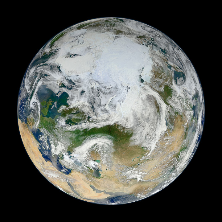
Mapping the Earth: The View from the Top - a Polar Perspective

The View from the Top

The View from the Top
Quick Cut & Paste:
There have been many images of the full disc of Earth from space—a view often referred to as “the Blue Marble”—but few have looked quite like this. Using natural-color images from the Visible/Infrared Imaging Radiometer Suite (VIIRS) on the recently launched Suomi-NPP satellite, a NASA scientist has compiled a new view showing the Arctic and high latitudes.
 
 
Source:
Ocean scientist Norman Kuring of NASA’s Goddard Space Flight Center pieced together this composite image of Europe, Asia, North Africa, and the entire Arctic. It was compiled from 15 satellite passes made by Suomi-NPP on May 26, 2012. The spacecraft circles the Earth from pole to pole at an altitude of 824 kilometers (512 miles), so it takes multiple passes to gather enough data to show an entire hemisphere without gaps in the view.


Instrument:  Suomi NPP - VIIRS
 VIIRS is a scanning radiometer that acquires data in 22 spectral bands, covering visible, near-infrared, and thermal infrared regions of the electromagnetic spectrum. It was designed to extend and improve upon the measurements of land masses, oceans, ice, and the atmosphere made over the past two decades by the Advanced Very High Resolution Radiometer (AVHRR) and the Moderate Resolution Imaging Spectroradiometer (MODIS).


Full Credits:
Image & text taken from NASA's Earth Observatory site.
Image by Norman Kuring, NASA/GSFC/Suomi NPP. Caption by Michael Carlowicz. Suomi NPP is the result of a partnership between NASA, NOAA and the Department of Defense.

                              
Further Reading:
 

Mapping the 2012 Election - Win Scenarios by Electoral State

Neat interactive pictorial display of potential scenarios for the 2012 Presidential race.


I particularly like the "rescrambling" of electoral wins to outplay certain voting events...


Full credits to the New York Times Politics e-page for "Electoral Map: Building a Path to Victory".

Mapping a Mars Landing - T-40 days to the Red Planet

Mapping a new type of Mars landing sequence- brilliant engineering "madness". T-40 days till touchdown on the Red Planet on 5 August.