I will always be an Indiana Jones fan. This movie series was one of those "cultural foundation points" that shaped my younger life. Full credits to Matt Busch for this neat project. Really impressive - this is a complication of not only movie referenced locations, but comic books, video games, the television series and even the theme park references (?!) as well.
Had to post this "best geek-out" video.
Showing posts with label google map. Show all posts
Showing posts with label google map. Show all posts
Thursday, September 22, 2011


Wednesday, September 08, 2010
Google's SketchUp 8 - 3D design and CAD-like rendering
The latest from Google's SketchUp 8 - very slick stuff.
Thursday, May 06, 2010
Mapping the Desktop - A 3-D visualization of organizing your work environment
This is a webcast of Google's latest conquest. How the leverage this into an OS in the tablet or mobile space? Well, we'll see. Very cool, but seems to be graphically intensive that might prohibit use.
Friday, April 30, 2010
How Fast is Your Zoom? Benchmarking zoom redraws vs. Google Maps
While I differ on the idea that this is the first "GIS in the cloud" - as far as
I can tell Alteryx has offered this for nearly a decade ( www.DemographicsNow.com & www.FreeDemographics.com ) - the zoom comparison is both compelling & relevant.
GIS Cloud WebMap Engine vs. Google Maps Engine (Zoom Slider Comparison) from GIS Cloud on Vimeo.
I can tell Alteryx has offered this for nearly a decade ( www.DemographicsNow.com & www.FreeDemographics.com ) - the zoom comparison is both compelling & relevant.
GIS Cloud WebMap Engine vs. Google Maps Engine (Zoom Slider Comparison) from GIS Cloud on Vimeo.
Friday, April 09, 2010
Map of Florida Area Roads and Traffic Growth
Florida Traffic Map - Map of Florida Area Roads and Traffic Growth
http://floridaroads.org/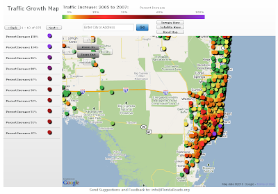
Found this site thru one of my GIS blog feeds. I would be curious to disect the data to look at differences in traffic congestion "off-season" and during the "snowbirds's arrival". The site allows for the standard "pan/zoom" or you and select by community/town of interest.
From the site:
"The Florida Traffic Growth Map highlights the busiest roads and highways. From 2005-2007, many roads and highways have seen at least a 50% increase in traffic. The map highlights the pace of change and increased utilization of Florida's infrastructure. In some areas the road conditions have changed significantly. The data is derived from the Florida Department of Transportation website. Each icon represents the location of a traffic counter and once clicked shows the annual average daily traffic (AADT) counts...."
http://floridaroads.org/

Found this site thru one of my GIS blog feeds. I would be curious to disect the data to look at differences in traffic congestion "off-season" and during the "snowbirds's arrival". The site allows for the standard "pan/zoom" or you and select by community/town of interest.
From the site:
"The Florida Traffic Growth Map highlights the busiest roads and highways. From 2005-2007, many roads and highways have seen at least a 50% increase in traffic. The map highlights the pace of change and increased utilization of Florida's infrastructure. In some areas the road conditions have changed significantly. The data is derived from the Florida Department of Transportation website. Each icon represents the location of a traffic counter and once clicked shows the annual average daily traffic (AADT) counts...."
Thursday, May 28, 2009
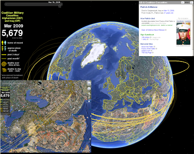
A Map for Memorial Day - Sobering remembrance
 I spent the Memorial Weekend in the Washington DC area. We celebrated my son's 8th birthday, toured the Air & Space Museum, and heard the roar of the Rolling Thunder bikers as they massed on the mall for remembrance of our soldiers' sacrifice.
This particular site (www.MapTheFallen.org) seemed to capture my mixed emotions on the two wars and the sacrifice born by our military. I wish I could bring them all back, and hope this site continues to geographically illustrate their deeds, and emphasize the eternal thanks we owe them all.
In the Google Earth environment, you are able to see home of record, approximate place of death, and other thematic/temporal representations.
Subscribe to:
Posts (Atom)